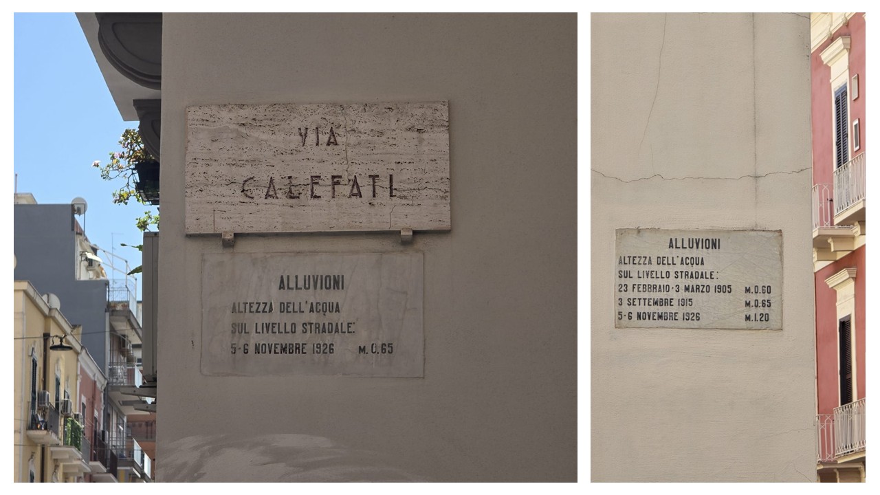
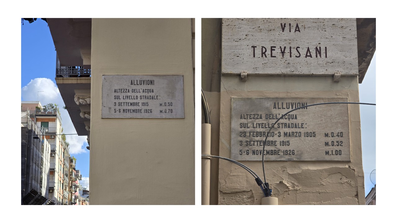
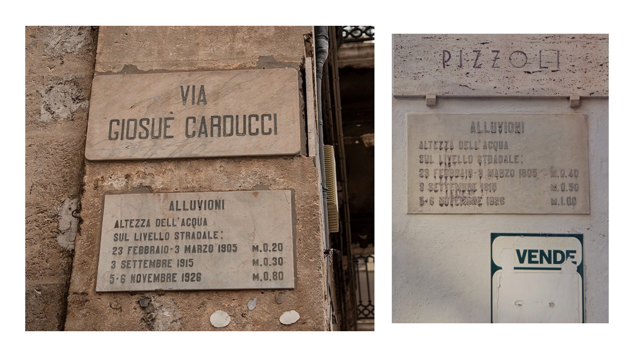
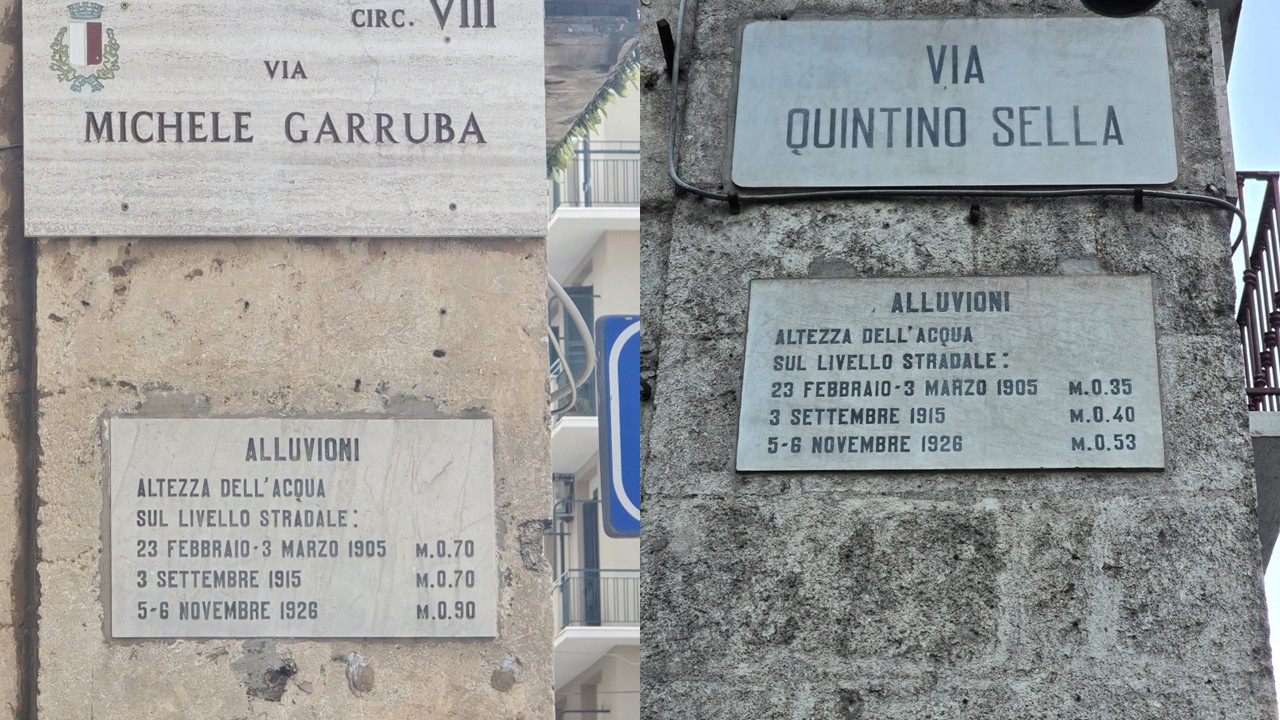
Photographs of stone plaques mounted at various points in the Libertà and Murat districts of Bari.
They record the water levels reached during the floods of 1905, 1915, and 1926.
credits: Roberto Rizzi, Università di Bari Aldo Moro
SOUTH RISK
From data collection to monitoring intervention. A southern history

They record the water levels reached during the floods of 1905, 1915, and 1926.
Scars of Stone. The Flood Plaques in Bari’s Libertà and Murat Districts
Not all memories are written in books: some remain etched into the walls. Walking through Bari’s
Murat district toward
the Libertà quarter, one can still stumble upon stone plaques that mark the height reached by
floodwaters during the
inundations of 1905, 1915, and 1926. At first glance, they look like modest urban signs, but
they are, in truth, scars –
traces of a city’s body wounded more than once. The plaques are set at the corners of busy,
working-class streets: in
the commercial heart of the city – Via Calefati, Via Garruba, Via Quintino Sella, the lower part
of Via Carducci – and
in the historic Libertà district – Via Trevisani, Via Crisanzio, Via Bovio, the upper part of
Via Carducci – where
water, mud, and debris once poured through. Each number carved into stone restores the vertical
dimension of disaster:
the water rising, silent and relentless, up to the point marked by human hands. It was a
technical gesture, bureaucratic
perhaps, yet one that still chills the observer a century later. The floods of 1905 and 1915 had
already been severe,
but it was the catastrophe of 1926 that impressed upon the collective memory the true scale of
destruction: streets
turned to torrents, houses swept away, entire neighborhoods swallowed in mud. Together, the
plaques recount a chronology
of fragility – not a single accident, but the obstinate recurrence of a fate inscribed in the
geology of the Bari basin,
and worsened by unchecked urban expansion. Nowhere was this more evident than in the Libertà
district. Born at the end
of the nineteenth century between the swamp of Marisabella and the gasworks, it had grown ever
denser: 2,3 inhabitants
per room in 1881, and many more in the decades that followed. Modest dwellings, poorly served
streets, precarious
drainage – Libertà had promised urban redemption but became instead an epicentre of
vulnerability. Each flood found easy
passage, turning roads into canals and courtyards into ponds. These plaques, set into the walls,
do not celebrate heroes
or victories. They are mute warnings, forcing today’s passer-by to lift their gaze and wonder:
what if the water came
back?
___Stefano Daniele & Francesco Paolo de
Ceglia
References
From data collection to monitoring
interventions and
risk prevention
Project realized by:
University of Bari Aldo Moro
INAF - Astronomical Observatory of Capodimonte
University of Naples Federico II
University of Messina
PROGETTO SOUTH RISK © 2026 ALL
RIGHTS
RESERVED
The exhibition is realized for the project:prin
pnrr
South-Risk
From data collection to monitoring
interventions
and
risk prevention
A southern history
P2022TA5M8