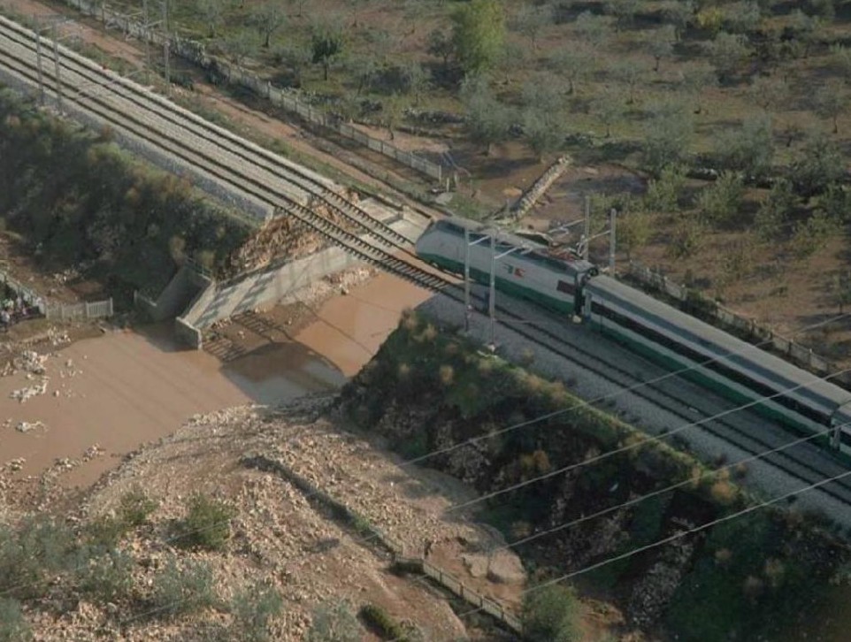
The collapse of the railway embankment in the lama Scappagrano
Gentile, F., Spanò, M. & Ricci, G.F. (2018). “Il reticolo effimero delle lame e il rischio idraulico della città di
Bari”, Geologia dell’Ambiente, 2, p. 22

SOUTH RISK
From data collection to monitoring intervention. A southern history
Gentile, F., Spanò, M. & Ricci, G.F. (2018). “Il reticolo effimero delle lame e il rischio idraulico della città di
Bari”, Geologia dell’Ambiente, 2, p. 22
Lessons from the Flood. 2005: Risk, Resilience, and the Memory of the Future
For decades after the 1926 flood, Bari experienced a long reprieve. Only in 1957 did a modest yet telling overflow
remind the city that water can always return to breach its bounds. In the meantime, Bari had changed its face: the
countryside had been urbanised, the lame (ancient streambeds) buried or confined in concrete, the soil sealed beneath
roads, railways, and buildings. From the 1930s to the 2000s, studies on land use within the Picone basin revealed a
shifting pattern: forested areas expanded until 1990, then began to decline, while urban zones grew steadily and without
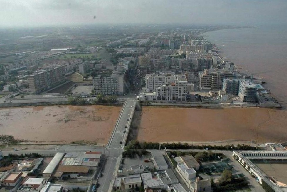
interruption. The consequences became clear in 2005. Between 22 and 23 October, an exceptional amount of rain fell
within a few hours: six people died, dozens were injured, rail and road links were torn apart, farmland was ravaged. The
images of the flood revealed a landscape at once familiar and new: collapsed bridges, submerged roads, a derailed train
in the lama Scappagrano – the very basin that once fed the Picone. Subsequent investigations uncovered a complex truth.
The works carried out after 1926 – such as the diversion canal of the lama Lamasinata and the reforestation of
Mercadante – had functioned as intended: the floodwaters did not reach Bari’s city centre. Yet the outskirts were
overwhelmed, where the hydrographic network intersected with modern infrastructures. The friction points between river
and road, between water and steel, multiplied. At Cassano delle Murge, the collapse of a road embankment caused five
deaths; between Acquaviva and Sannicandro, an Eurostar train derailed after the failure of a railway embankment. The
2005 flood served as a stark reminder that geology cannot be erased by urban design. Natural basins, if neglected, will
always reclaim their space. And yet, that event also carried a lesson of hope. The defensive works of the previous
century proved that prevention succeeds only when engineering is joined with care for the landscape. Today, new
flood-risk maps, hydrological modelling, and a return to more conscious territorial planning mark a change in direction.
The history of water in Bari, then, is not merely a record of disasters but an exercise in civic responsibility. The
2005 flood revealed once again the fragility of human boundaries – but also the tenacity of collective memory. For
understanding the past of water – its courses, its excesses, its absences – may well be the only way to inhabit the
future with intelligence. Today, the future demands that such memory be turned into active knowledge. Recent research on
environmental risk and on the history of scientific institutions in southern Italy – including that at the core of South
Risk. From Data Collection to Monitoring Interventions and Risk Prevention. A Southern History project – shows that
understanding natural phenomena also means understanding the society that inhabits them. The lame, the forests, the
canals are not merely geological legacies, but signs of a relationship to be rebuilt between humankind and the
environment, between citizens and institutions. The challenge lies in bringing together science and memory, foresight
and care: adopting sustainable policies, fostering awareness, and building resilient communities. After all, cities
endure not because they resist water, but because they learn to live with it. But the climate, meanwhile, is changing.
Heatwaves, sudden downpours, and the tropicalisation of the Mediterranean demand new forms of adaptation. The task is no
longer merely to defend against water, but to rethink how we inhabit the land: buildings, schools, infrastructures, and
landscapes must be redesigned not only to withstand but also to respond to change. The same applies to agriculture –
once a measure of Apulia’s prosperity, now among the sectors most vulnerable to the new climatic regime. Prolonged
droughts, erratic rainfall, and soil salinisation are transforming crops, practices, and economies. The challenge is not
simply to protect fields from floods, but to make them responsive to scarcity: to redesign irrigation systems, to
restore an ecological balance grounded in innovation yet mindful of the past. Recent studies on the resilience of
Mediterranean built and rural heritage show that future safety will depend not only on technical efficiency but on
collective awareness. Understanding the history of water, in this sense, is not an act of remembrance but of foresight.
For cities – and the lands that sustain them – endure not only by resisting the water, but by learning, at last, to live
with it.
___Stefano Daniele & Francesco Paolo de Ceglia
References
From data collection to monitoring
interventions and
risk prevention
Project realized by:
University of Bari Aldo Moro
INAF - Astronomical Observatory of Capodimonte
University of Naples Federico II
University of Messina
PROGETTO SOUTH RISK © 2026 ALL
RIGHTS
RESERVED
The exhibition is realized for the project:prin
pnrr
South-Risk
From data collection to monitoring
interventions
and
risk prevention
A southern history
P2022TA5M8