When Rain Becomes a Danger: the Case of Giampilieri in 2009
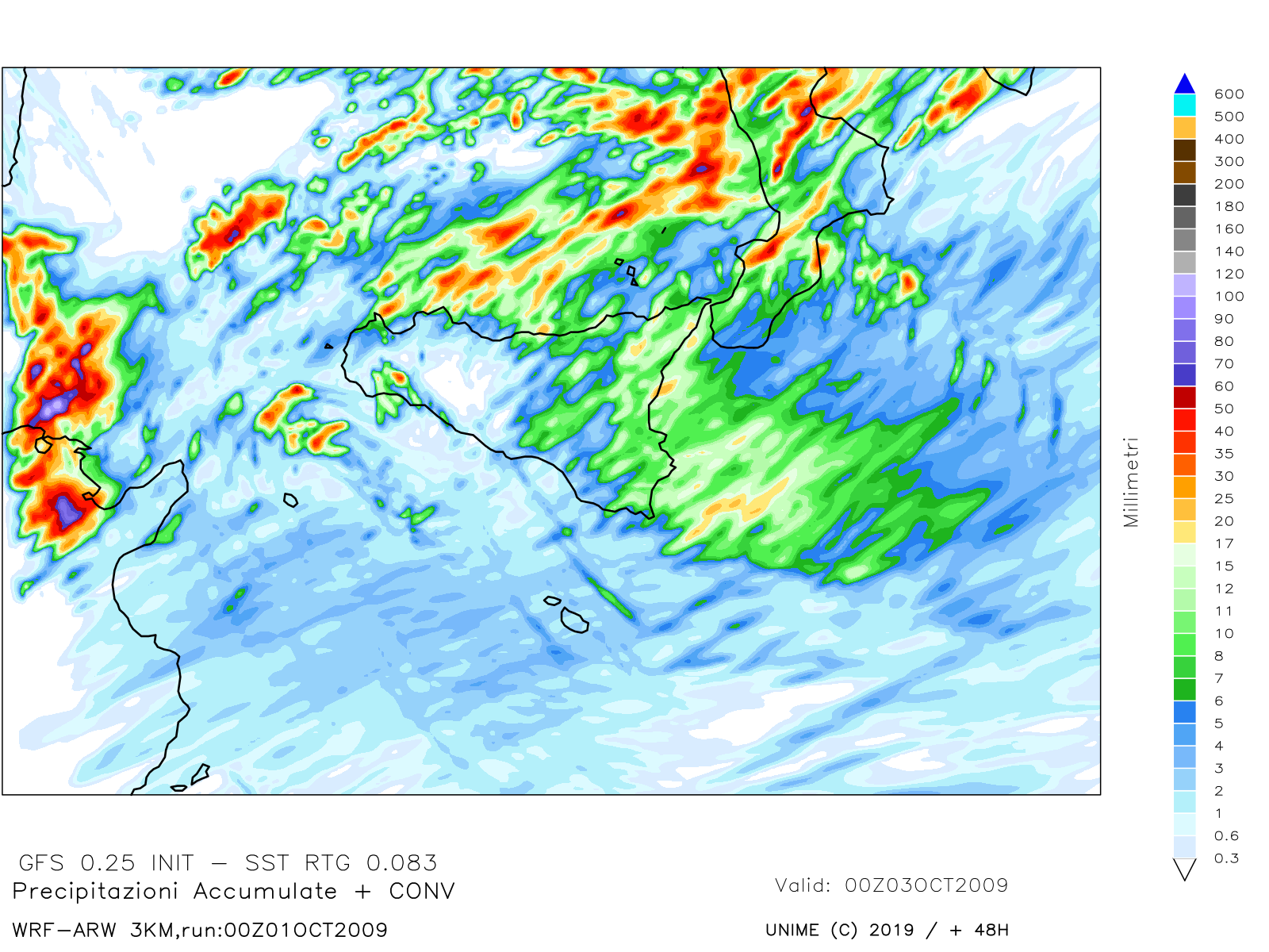
The image illustrates the map obtained from the Weather Research and Forecasting Model (WRF) simulation and represents
the 48-hour rainfall accumulation forecast (from 00:00 UTC on 1 October 2009 to 00:00 UTC on 3 October 2009) for the
extreme event that occurred in Giampilieri. It shows a predicted precipitation distribution pattern for Sicily. The map
from WRF configuration n. 3 showed the best representation of the predicted pluviometric distribution, highlighting the
greatest accumulations on the Ionian coast of eastern Sicily, particularly in the Messina area.
This study focuses on the analysis of the extreme weather event that struck the Ionian area of Messina, specifically the
hamlet of Giampilieri, on 1 October 2009. Although the event also affected neighboring localities (such as Molino,
Altolia, Briga, Scaletta Zanclea, and Itala), the analysis focuses on Giampilieri, where the extremely localized event
tragically caused 37 victims and triggered up to a thousand debris flows.
The event was triggered by a complex atmospheric framework, which included a low-pressure minimum between Tunisia and
the major islands, two Mesoscale Convective Systems (MCSs), a self-regenerating thermal convective storm, and high Sea
Surface Temperature (26°–27°C). The cumulative rainfall was extreme (>220 in 7 hours on 1 October), compounded by the
preceding soil saturation (about 500 mm accumulated since 15 September).
preceding soil saturation (about 500 mm accumulated since 15 September).
The analysis was carried out using a multidisciplinary approach:
___1 - Atmospheric Modelling: Over 30 simulations were performed with the WRF model. The best configuration (n. 3) provided a
good representation of the general pattern, but underestimated the rainfall peaks, highlighting the extremely localized
nature of the event and the need for higher grid resolution and data assimilation techniques in future studies.
___2 - Geomorphological Analysis: The debris flows that struck Giampilieri and other villages were analyzed using GIS and field
surveys. The maximum landslide susceptibility index was found to be correlated with the mobilization of detrital covers
on metamorphic substrates (paragneiss, schists, phyllites) in areas with slopes between 35° and 45°.
___3 - Social Impact: The event exposed severe institutional shortcomings in prevention and post-emergency management,
including delayed funds and unjustified accusations of illegal construction. Despite this, the population showed great
resilience, refusing relocation and organizing reconstruction efforts.
The study concludes that an integrated approach (atmospheric modeling, geomorphological mapping, and monitoring) is a
valid tool to support Administrations in land-use planning and risk management. The results suggest that proper soil
maintenance and preventive measures could have significantly mitigated the destructive impact.
___Adila Sturniolo, Agostino Semprebello, Maria Teresa Caccamo, Salvatore Magazù
References
Caccamo, M.T., et al. (2025). “Customization of Limited Area Model for complex orography
territories: the WRF and the
WRF-Chem UniMe model” Atti della Accademia Peloritana dei Pericolanti Classe di Scienze
Fisiche, Matematiche e
Naturali,103(1), A2.
Castorina, G.,et al. (2022). “Impact of the Different Grid Resolutions of the WRF Model for
the Forecasting of the
Flood Event of 15 July 2020 in Palermo (Italy)”, Atmosphere, 13(10), 1717.
Castorina, G., , et al. (2023). “Performance of the WRF Model for the Forecasting of the
V-Shaped Storm Recorded on
11–12 November 2019 in the Eastern Sicily”, Atmosphere 14(2), 390.
Puglisi C., et al. (2013). “Valutazione della pericolosità da frana nel territorio del Comune di Messina”, Rapporto
tecnico ENEA, 18.
___
___